Dear readers and followers,
Google Blogger somehow corrupted this post making it unreadable by omitting words, phrases and even entire paragraphs. I'm in the process of re-creating the post. Please check back...almost done! Sorry for the inconvenience.
Doctor Jack
"I wonder whether the boys who live in Roxbury and Dorchester are ever moved to tears or filled with silent awe as they look upon the rocks and fragments of "puddingstone" abounding abounding in these localities... Yet a lump of puddingstone is a thing to look at, to think about, to study over, to dream upon, to go crazy with, to beat one's brains out against. Look at that pebble in it. From what cliff was it broken? On what beach rolled by the waves of what ocean? How and when embedded in soft ooze, which itself became stone, and by-and-by was lifted into bald summits and steep cliffs, such as you may seen on Meetinghouse-Hill any day-yes, and mark the scratches on their faces left when the boulder-carrying glaciers planed the surface of the continent with such rough tools that the storms have not worn the marks out of it with all the polishing of ever so many thousand years?"
The Professor at the Breakfast Table, Oliver Wendell Holmes, Sr., 1964
 |
| The Roxbury Conglomerate displaying its sandstone matrix and variously-derived clasts |
When I first moved to Massachusetts many years ago, I didn't know the first thing about geology. I had certainly heard of plate tectonics but didn't really understand it or knew nothing of its relevance. I never learned a thing about it in high school back in the 60's. Tectonics was barely in its infancy when I graduated. Now living in a western suburb of Boston, I was intrigued by the composition of the stone wall in my yard. In fact, all the walls in town looked the same. They were made of a sandy-textured stone with big, round rocks stuck in it. I read that it was called puddingstone and that it traveled a long distance to arrive here. That was the beginning of my geological journey, that wall. This post (and the one that follows), in fact my entire blog, is the result of that enlightenment.
THE STATE ROCK
The Roxbury Conglomerate is the state rock of Massachusetts, named as such in 1983. It forms much of the basement rock under the city of Boston and its surrounding environs. What's more, a great many of the older structures in Boston are constructed of it! What is the Roxbury Conglomerate? How did it form? When did it form? Why was it used as a building stone as opposed to other rocks that were more plentiful and more massive in New England? Much is known, but in spite of investigation and research that has spanned over a century, the depositional and tectonic history of the Roxbury Conglomerate and the Boston Basin, in which it is found, has remain somewhat controversial and enigmatic.
COMING TO TERMS
Geologists are partial to changing the names of large landmasses (also called cratons) and bodies of water in order to denote a change in the time frame, a potentially confusing situation for the layman (and even amateur geologist) but necessary nonetheless. Understanding such changes in nomenclature is relevant to our discussion in this post and in reading the literature. So, here's my attempt at a simplistic explanation.
The Earth's tectonic plates have been rearranging the continents and oceans like pieces of an enormous jigsaw puzzle for many millions of years, actually billions. A continental landmass that existed during the Cambrian Period undoubtedly would have drifted to another location during say the later Permian Period. The system of nomenclature provides for the naming of a landmass during one time and location, and allows for a uniquely different name for the landmass during a different time and location. In that way, the name of the landmass automatically conveys a general time-frame and implies a specific relationship to other landmasses and bodies of water. It's that simple.
For example, North America is often referred to as proto-North America to indicate the continental landmass that existed any time before the modern one, obviously a very broad sense of time. More specifically, Laurentia refers to proto-North America during the early Paleozoic. During that time frame, as we shall see, the smaller terrane of Avalonia and Baltica (a micro-continent that eventually formed parts of Europe, Scandinavia and Siberia) collided with Laurentia. That formed Laurussia (or proto-North America) during the Middle Paleozoic. Laurussia, in older, pre-tectonic terminology, is also referred to as the Old Red Sandstone continent during the Devonian. Laurasia is often used interchangeably in the literature for Laurussia (technically includes the additional accretion to Laurussia of the landmasses of Siberia, Kazakhstania, and the North China and East China cratons). During the late Paleozoic, the continent of Gondwana collided with Laurussia, and that formed the massive supercontinent of Pangaea, yet another proto-North America. Pangaea ultimately drifted apart during most of the Mesozoic, leaving Laurussia to become the modern continent of North America and all the remaining continents to be dispersed throughout the globe. You can follow the name changes on the various maps below taking note of their time frames.
By the way, we use the same concepts of nomenclature for bodies of water. The Iapetus Ocean (often called the proto-Atlantic Ocean) and Rheic Oceans that existed between Gondwana and Laurentia were consumed when Pangaea formed, only to give birth to its oceanic successor, the Atlantic Ocean, when Pangaea finally rifted apart. To quote the famous Scottish geologist John Hutton, "we find no vestige of a beginning, no prospect of an end."
THE EVOLUTION OF AVALONIA AND ITS JOURNEY ACROSS THE IAPETUS
In order to fully appreciate the origin and geologic history of the Roxbury Conglomerate let's examine the global "big picture" for the last billion years. In particular, let's trace the path that Avalonia assumed during its inception as a juvenile magmatic-arc, its accretion to, and subsequent drifting from the northern margin of Gondwana, it stectonic journey across the Iapetus Ocean, and its collision with eastern Laurentia. For, it is juvenile Avalonia where the Roxbury Conglomerate was deposited. Note that there is not universal acceptance amongst geologists regarding the timing and tectonic provenance of Avalonia's history.
Durng the late Precambrian (Neoproterozoic ca. 1100 Ma), a massive supercontinent commonly referred to as Rodinia formed and broke up (ca. 800 to 700 Ma). The timing of break-up and the exact fit of its elements remain sonewhat controversial. Regardless, Rodinia's rifting apart eventually spawned two smaller supercontinent siblings called Laurentia and Gondwana (also Gondwanaland). Gondwana included most of the continental landmasses in today's Southern Hemisphere. Proto-Avalonia (during the Proterozoic) has been suggested to possibly have a peri-Rodinian, island-arc provenance in spite of the fact that undisputed basement upon which it developed is nowhere, unequivocally exposed (with the exception of peri-Gondwanan terrane called Tregor-La Hague in northern France dated ~2 Ga). Regardless, the origin of the proto-Avalonian terrane remains controversial.
ANCIENT RODINIA RIFTS APART SPAWNING LAURENTIA AND GONDWANA
These Mollweide Projections look at the Earth as a flat map. They accurately depict area at the sacrifice of angle and shape. This map is an interpretive illustration of the supercontinent of Rodinia after its breakup in the Late Precambrian (Neoproterozoic). Its rifted-remnants became the somewhat smaller continents of Laurentia and Gonwana. Laurentia eventually formed most of North America. Gondwana was an amalgamation of the modern continents of South America, Africa, India, Australia and Antarctica.
AVALONIA RIFTS FROM GONDWANA
Rodinia has rifted into the two aforementioned major landmasses. The Iapetus Ocean separates equatorially-located Laurentia from australly-located Gondwana. In the Middle Cambrian, the juvenile, island-arc terrane of Avalonia (shown as "new England and Nova Scotia" on the map) rifted from the northern margin of Gondwana. Thus began a tectonic journey that would transport Avalonia across the closing Iapetus Ocean and culminate with its collision with Laurentia. Located within the terrane of Avalonia, the foundation on which the city of Boston was built formed from the Neoproterozoic rocks that originated in the mid- to high-latitudes region of the Southern Hemisphere.
SOUTH POLAR VIEW
This south polar perspective during the Early Ordovician, Avalonia (labelled as such) is beginning to rift from Gondwana and will then initiate a trajectory across the Iapetus Ocean, along with Baltica, towards Laurentia. Equatorially-located Laurentia (far left) awaits their collision.

 |
| Modified from Ron Blakey and Colorado Plateau Geosystems, Inc. |
AVALONIA RIFTS FROM GONDWANA
Rodinia has rifted into the two aforementioned major landmasses. The Iapetus Ocean separates equatorially-located Laurentia from australly-located Gondwana. In the Middle Cambrian, the juvenile, island-arc terrane of Avalonia (shown as "new England and Nova Scotia" on the map) rifted from the northern margin of Gondwana. Thus began a tectonic journey that would transport Avalonia across the closing Iapetus Ocean and culminate with its collision with Laurentia. Located within the terrane of Avalonia, the foundation on which the city of Boston was built formed from the Neoproterozoic rocks that originated in the mid- to high-latitudes region of the Southern Hemisphere.
SOUTH POLAR VIEW
This south polar perspective during the Early Ordovician, Avalonia (labelled as such) is beginning to rift from Gondwana and will then initiate a trajectory across the Iapetus Ocean, along with Baltica, towards Laurentia. Equatorially-located Laurentia (far left) awaits their collision.
AVALONIA BEGINS A TECTONIC JOURNEY ACROSS THE IAPETUS
During the Late Ordovician, Avalonia rifted from Gondwana, which spans the South Pole to north of the equator (seen off to the right). Along with Baltica (which formed Scandinavia and parts of northern Europe), the two landmasses drifted towards Laurentia, as the Iapteus Ocean closed. The rifting of Avalonia from Gondwana occurred diachronously with the formation of the intervening Rheic Ocean, which will ultimately close during the formation of Pangaea. The basement rocks of the Boston Bay Group, including the Roxbury Conglomerate, have already formed on Avalonia and are now tectonically "travelling" with it. At about the Ordovician-Silurian boundary, while drifting in the Iapetus towards Laurentia, Avalonia amalgamated (a soft, oblique docking) with Baltica in equatorial paleolatitudes. That amalgamation consumed the intervening Tornquist Sea (see map).

AVALONIA AND BALTICA ZERO-IN ON LAURENTIA
During the Middle Silurian, Avalonia and Baltica are about to collide with Laurentia, which will become Laurussia. The Iapetus Ocean is nearly consumed at the expense of the opening Rheic Ocean. Gondwana is growing near. It too will collide with Laurussia. After the consumption of the Iapetus Ocean with the collision of Avalonia and Baltica to Laurentia, a new ocean will form called the Atlantic with the rifting apart of Pangaea. In Greek mythology, Iapetus was the father of Atlantis.
During the Middle Silurian, Avalonia and Baltica are about to collide with Laurentia, which will become Laurussia. The Iapetus Ocean is nearly consumed at the expense of the opening Rheic Ocean. Gondwana is growing near. It too will collide with Laurussia. After the consumption of the Iapetus Ocean with the collision of Avalonia and Baltica to Laurentia, a new ocean will form called the Atlantic with the rifting apart of Pangaea. In Greek mythology, Iapetus was the father of Atlantis.

THE ACADIAN-CALEDONIAN OROGENS
During the Early Devonian, the collision of Avalonia with Laurentia will initiate a major
mountain-building event called the Acadian Orogeny in the proto-North America region. With the accretion of Baltica and Laurentia, the Caledonian Orogeny formed a geographically distinct orogenic belt in the proto-European region (Great Britain and Scandinavia) of the landmass. Laurentia will become Laurussia after its collison with Avalonia and Baltica. Closure of the Rheic Ocean was facilitated by subduction beneath the southern Baltican margin (Variscan belt); whereas, arc-magmatism developed on the previously accreted Avalonian terranes, and by southward subduction beneath the northwestern margin of Gondwana (Appalachian-Ouachita belt), where Laurentia forms the lower plate. The eventual collision of Gondwana with Laurussia (Mississippian) will consume the Rheic Ocean and form Pangaea by the end of the Permian.

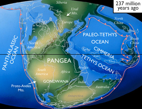
GONDWANA'S LAURUSSIAN COLLISION FORMS PANGAEA
During the Late Triassic, with Gondwana having slammed into Laurussia, Avalonia has become internalized within Pangaea. The collision has initiated the Alleghenian-Herycnian/Variscan Orogeny, a major mountain-building event. Early rifting of Pangaea is initiating in the north. Note that both the Iapetus and Rheic Oceans have long been consumed, leaving the Panthalassic Ocean as the major global body of water. The rifting of Pangaea began in the north during the Early to Middle Jurassic with the formation of the North Atlantic Ocean.
ALLEGHENIAN-HERCYNIAN/VARISCAN OROGENS
During the Pennsylvanian, the collision of Gondwana with Baltican Laurussia and the peri-Gondwanan terranes portion of Laurussia sequentially with its West African margin docking with southern Baltica and eastern Laurussia (Hercynian/Variscan Orogens in southern Europe and the Alleghenian Orogen in proto-North America); whereas, Gondwana's Amazonian margin collided with southern Laurussia (Ouachita Orogen). The resulting Variscan-Alleghenian-Ouachita belt was arguably the largest collisional orogen of the Paleozoic, and sutured Gondwana and Laurussia to form Pangaea.

RIFTED PANGAEA PLACES THE BOSTON BASIN IN COASTAL NEW ENGLAND
In the Late Cretaceous, Pangaea has rifted apart and the contemporary continents of the world have dispersed apart throughout the globe. Previously accreted Avalonia, now referred to as the Southeastern New England Avalon Zone, which includes the Boston Basin, has assumed a passive location on the coast of eastern North America. The majority of the eastern seaboard of present day North America was derived from similar but smaller peri-Gondwanan terranes (e.g. Ganderia, Carolinia, Meguma, etc.), some from an African and others from an Amazonian locale. A corollary to the breakup of Pangaea was the redistribution of early Paleozoic parts of Laurentia and Avalonia (giving rise to the terminology of West and East Avalonia) on either side of the North Atlantic, where we find them today. Therefore, in addition to New England and Atlantic Canada, Avalonia formed parts of southeastern Ireland, southern Britain, and a substantial area of Europe surrounding Belgium, after Pangaea rifted apart.

THE BIRTH OF THE BOSTON BASIN
Fabulous. I love such a fantastically huge perspective on human existence. I wonder if such a perspective could positively alter human behaviour at all? Probably not! Thanks for all of this (gotta get back to work!)
ReplyDeleteHello,
ReplyDeleteI am writing a paper and I wanted to use one of your images (458 million years ago) in it. In order to cite information correctly I need to know where did you get that image from?
Sophia,
ReplyDeleteAs mentioned in the text of my post, the map is from scotese.com.
A couple of questions.
ReplyDeleteFirst, will you ever reconstruct the mangled Roxbury Conglomerate blog? I read it once before Google Blogger mangled it; I'd love to read it in its entirety.
Second, is there any chance that you can visit us here in Oregon? We can offer volcanoes in various flavors, terranes (at least two) and a magnitude 9+ time bomb just off our coast.
Keep up the good work. That goes for your daughter's work, too.
It appears that my reconstruction question was untimely. Oops!
DeleteThe invitation to explore Oregon geology (or Oregon in general) still stands.
Again, keep up the good work.
In your quotation from The Professor at the Breakfast Table - don't you mean 1860, rather than 1964? Oliver Wendell Holmes, Sr. died in 1894. The "Professor" was first published in 1860. But otherwise, fascinating reading! Thanks.
ReplyDeleteThe girls and boys of Roxbury are in Awe of puddingstone now! I am a Preschool teacher and our campus is 100 years old. We play on large protruding puddingstones. Thank-you for confirmation of connection Roxbury bedrock formation connection to West Africa. I can now make a known connection geographically for my students. I have a fuller understanding geologically of the erosion that took place
ReplyDelete600 million years ago in the Roxbury area. I have always loved puddingstone I am now amazed at its
creation and how it applies to earths structure. I am thinking of writing a picture book on this topic!!!
Thank you for the wonderful comment! I'm very pleased that both you and your students can make such a connection. And thanks for visiting Written In Stone!
DeleteOne more thought....It's important to know that considerable debate exists regarding the providence of the peri-Gondwanan terrane of Avalonia, the volcanic arc that carried the Boston Basin (and Roxbury conglomerate) to proto-North America (and Boston). Did it originate from the Amazonia or West African craton of Western Gondwana? Most researchers gravitate to the former, but not all. Happy geology!
Delete